2025 Facilities Master Plan
◆ Architecture
■ Master Planning
● Interior Design
■ Master Planning
● Interior Design
2025 Facilities Master Plan
On August 21, 1916 a new highway built by the State of Colorado over Wolf Creek Pass was opened. Along with the new modern highway, came electricity and the telephone. The Old West was gone. The lumber boom lasted almost into the 1920's, by which time the easily accessible timber had all been logged. Following shortly after was the Great Depression and World War II. Many of the rural residents of the County were forced to move either into town or further away out of the County to work in defense manufacturing plants.
In the 1970’s, the Pagosa Springs area and Archuleta County, became a beacon for land developers. With all the beautiful scenic panoramas of mountains, forests and streams, buyers with extra money to spend came from all around the Country and helped grow Archuleta County into the unique experience you have today.
In 1859, the U.S. Army sent out an expedition through the Archuleta County area headed by Captain John Macomb, and soon after in 1860 gold was discovered in the San Juan Mountains. For the next 30 years, prospectors and settlers poured in to the area. In 1878, Fort Lewis was established along the San Juan River next to the great Pagosa Hot springs to protect settlers and travelers from the Indians. With Calvary troops, cowboys and Indians, gunfights and stagecoach holdups, Archuleta County was the embodiment of the Wild West.
The growth of cattle and sheep ranching, as well as the development of the lumber industry, led to a booming economy in the 1890's and helped to bring the railroad to Pagosa Springs in 1900. With the advent of the railroad running between Silverton, Durango, Chama and points east along the southern boundary of the county, the lumber industry flourished and became the dominant sector of the economy. The railroad also boosted ranching by providing a practical way to ship cattle and sheep to market.
As part of the master planning process, it is important to include forecasts for enrollment to understand facility needs moving into the future. This master plan includes demographic analysis conducted by Western Demographics. The initial analysis was conducted in July 2007. There is also an updated demographics report for 2025.
Capacity and Enrollment Analysis
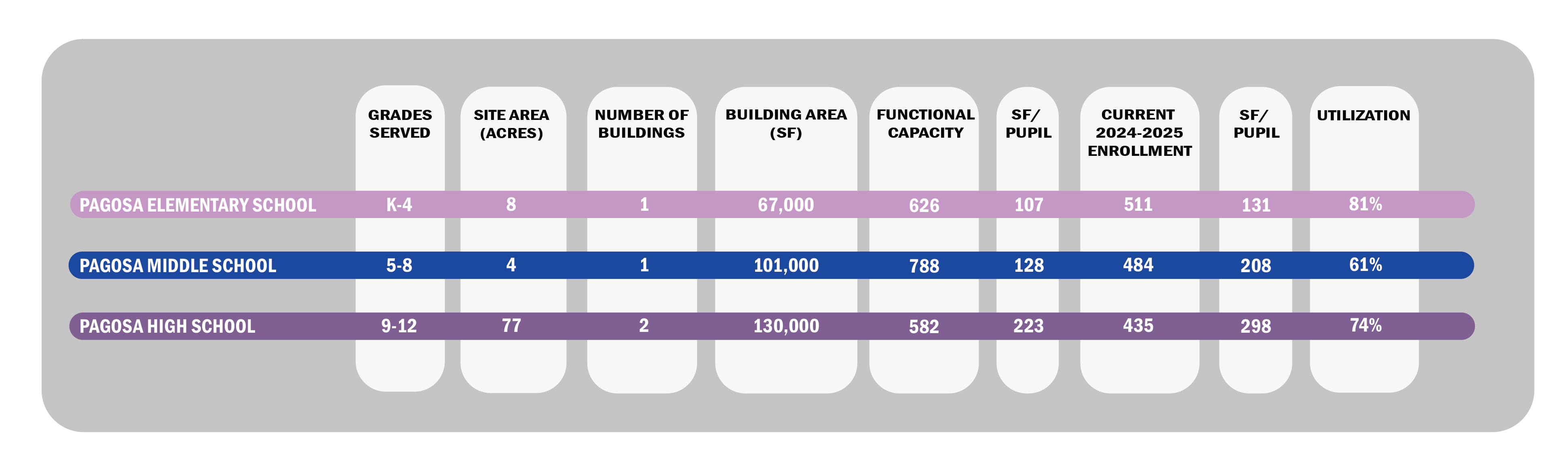
The chart above also includes current building student capacity and how it relates to the anticipated 2024 enrollment through the anticipated 2030 enrollment at each school. This allows a quick analysis of how a building facility will handle the student enrollment projections over the next 5 years. Using the District class size per teacher requirements, all the schools are under capacity and can accommodate any future growth.
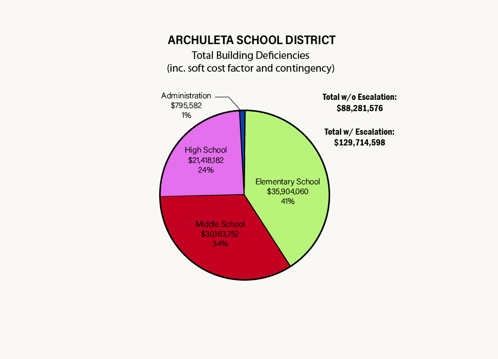
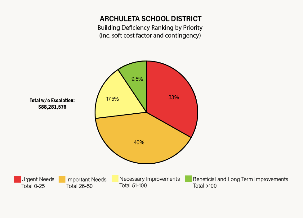
The pie charts provided above consolidate this information and create a comparison of deficiency categories, and comparison of overall district-wide deferred maintenance by facility.
Detailed individual assessments for each facility can be found in the links provided under the Properties tab below.
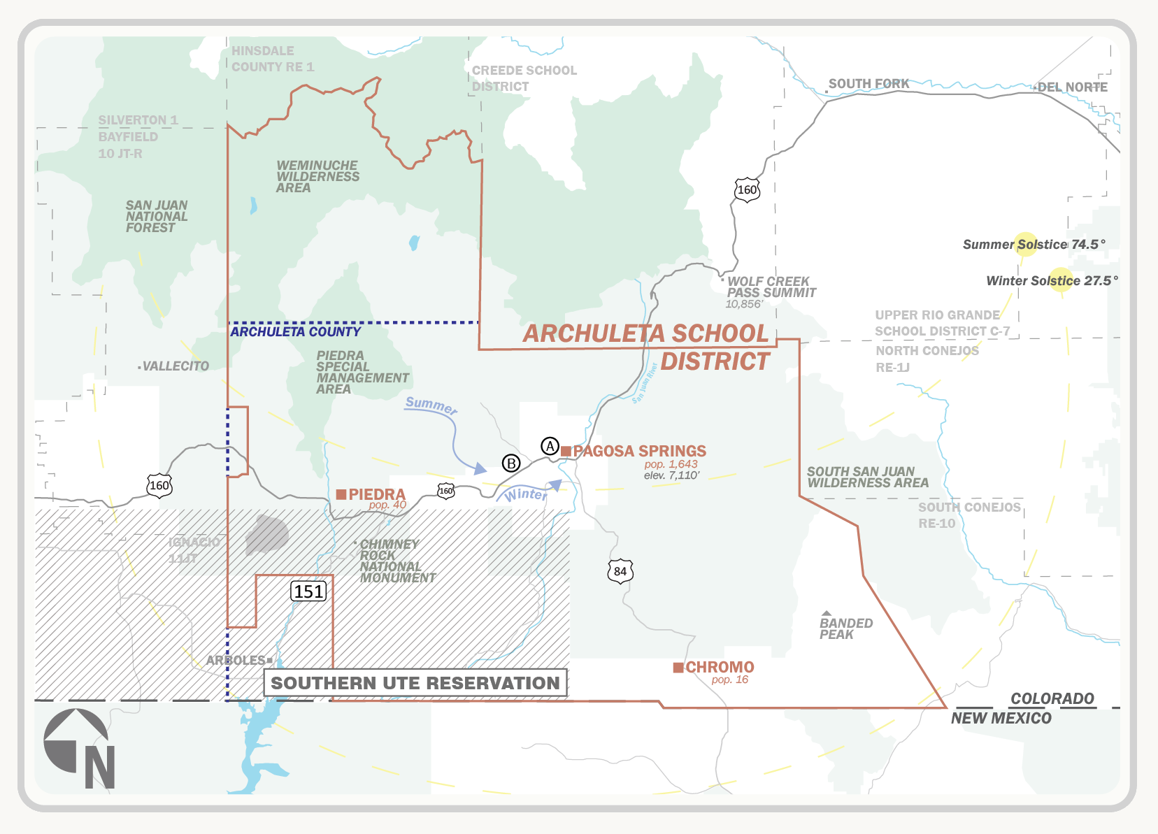
Pagosa Springs touches New Mexico border, 152 miles north of Santa Fe, and 285 miles southwest of Denver, Archuleta County is surrounded by nearly 3 million acres of National Forest with easy access to the Rocky Mountains and southern Colorado’s incredible landscape which is a doorway to the four seasons of outdoor picturesque towns.
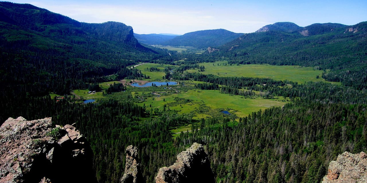
The town of Pagosa Springs is surrounded by the largest contiguous wilderness area in the U.S. Nestled at an altitude of 7,000 feet with panoramic views of the San Juans, it's one of the most popular resort towns in Southern Colorado.
In the fall of 2024, RTA conducted an online survey to parents, students, staff and community members. With over 159 responses in English and Spanish, the school district was able to gather important data on stakeholder perceptions of the school facilties and perceived needs. Refer to the links below for access to the full survey results.
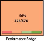
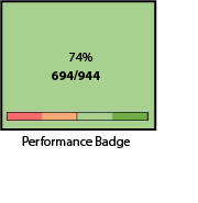
Educational Adequacy Assessments measure how well the facility supports the instructional program in the school. This is not an assessment of the physical condition of the school- the roofing, the windows, etc., which rates the various building systems. This is an assessment of the learning spaces compared to the program needs at that school. For example, if a district's music program includes an elementary component, each elementary school should have a music room with an appropriate learning environment, good acoustics, and space to store instruments or other equipment.
For each type of instructional space, the assessment includes four components:
Learning Environment - The room should provide an inviting and stimulating environment for learning, including HVAC, acoustics, etc.
Size - The room should meet the size standard set by the district/state.
Location - The room should be appropriately located based on the program needs: quiet, noisy, near the entrance, etc.
Storage and Fixed Equipment - The room should have appropriate safety equipment and storage for teacher/student materials.
In addition to the instructional Spaces, the adequacy assessment also includes the exterior of the building, e.g., traffic patterns, parking and access to the school, safety issues (lighting, signage, and secure entrances), play and athletic areas, and infrastructure that supports technology readiness.
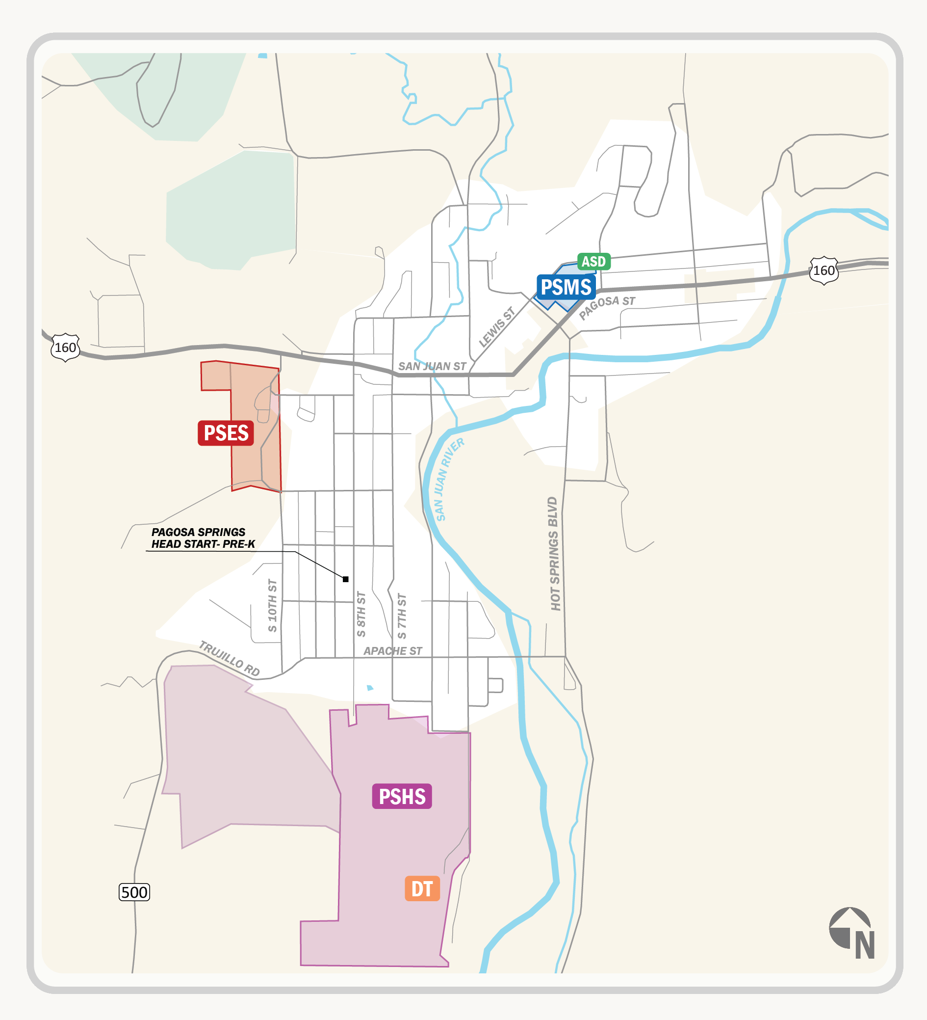
Pagosa Springs Elementary School scored 324/576 giving it a 56%. The highest scoring section is Core Program and Shared Spaces at 63%. The lowest scoring is Outdoor Spaces and Amenities. The main issues observed are the lack of bike racks, non-accessible play equipment, and missing outdoor instructional space.
Pagosa Springs Middle School scored 511 out of a potential 924, giving it an 55% adequacy score. The highest scoring section is at %. Property Boundary & Traffic Flow is the lowest category at 34%. The main concerns are various site constraints, lack of parking, and insufficient and missing outdoor amenities.
Pagosa Springs High School scored a 74% in the Educational Adequacy Assessment. It received 694 points out of the 944 potential points. All of the sections scored atleast 65% adequate. Areas for improvement include ADA accessible routes, collaboration spaces, and the addition of bike racks.

Thank you for taking the time to review and consider our Facilities Master Plan. Share your thoughts by email with us at